| Commands | CAPCAD_GEO_POINT_IDENTIFY (shortcut CC), CAPCAD_GEO_LATLON (shortcut LL), CAPCAD_GEO_CRS, CAPCAD_GEO_CRS_QUERY |
| Shortcuts | CC = identify / convert a coordinate; LL = quick latitude-longitude |
| Ribbon | CapCad tab › GIS panel › Identify split button › Coordinate Conversion: Point [CC] and Quick LatLong; GIS panel › Data split button › Coordinate System Set; the same Coordinate System entry also appears on the Manage panel › Project split button |
| Category | GeoData |
| Forms | CoordinateIdentifierForm, title "Coordinate Conversion" (modeless); CoordSysForm, title "Coordinate systems" (modeless) |
| Hosts | AutoCAD, BricsCAD, GstarCAD, ZWCAD, ARES Commander (all four commands) |
| Also opens | Batch conversion… opens Batch and entity coordinate conversion; Localizar em eixo… opens the Station Navigator form (see Notes); Street names… opens the street page of CAPCAD_LABEL |
Paste any coordinate and see all the others. The CAD knows where the point sits in the drawing; it does not know which system the drawing is in, nor what latitude and longitude that means.
- Takes whatever you have to hand. UTM, decimal latitude-longitude, degrees-minutes-seconds with N/S/E/W — and even a whole Google Maps or OpenStreetMap link pasted in.
- Works out for itself whether it is UTM or lat-long. You do not choose an input type; the program decides from the range of the values and shows what it detected.
- Brings the station with it. If the drawing has an alignment, the same reading shows the station as
0+000. - From the drawing to the map in one click. OpenStreetMap, Google Maps and Street View open on the point read, and the coordinate goes to the clipboard.
- And back into the drawing. One button inserts a point at the coordinate read, in the drawing's own system.
- The coordinate system is recorded where it belongs. On the project, on the alignment or in the dwg itself — and every other CapCad GIS command then uses it.
What it does
This page covers four commands that work on one point at a time, and on the coordinate system that gives that point meaning.
The coordinate system is an acquisition chain, not a single setting. Whenever a GIS command needs to know which system the drawing is in, it walks, in this order: (1) the coordinate system recorded on the active alignment, (2) the value recorded in the dwg, (3) the Civil 3D system, if there is one and the drawing is set up to use it, (4) the last system used in the session, (5) the culture default (in the United Kingdom profile, BNG), and finally (6) the project setting, the session's temporary system and, again, the last used. The first that answers wins. CAPCAD_GEO_CRS is the form that records the value; CAPCAD_GEO_CRS_QUERY is the query that tells you what the chain returned.
The recorded value is a short string the converters understand: UTM-23 (zone 23 south, SIRGAS 2000), UTM-23-SAD69, UTM-23S / UTM-23N for anywhere in the world, EPSG:31983 for any EPSG code, or Undefined.
Read the coverage section before you rely on this. The lists offer far more systems than actually convert. See What actually converts below; for a reader working outside South America it is the most important part of this page.
CAPCAD_GEO_POINT_IDENTIFY (CC) opens a modeless form with an input box that takes almost anything, and fills in at once: the station on the alignment, the projected pair (E,N / X,Y), the decimal latitude-longitude and the same in degrees-minutes-seconds. From there you copy it, insert a point in the drawing, or open the place on a map. The right-hand column searches an address on Google Places and uses the coordinate it finds as the input.
CAPCAD_GEO_LATLON (LL) is the form-free version: click a point, get lat,lon in a dialog and on the clipboard, click another, until you press Esc.
CAPCAD_GEO_CRS_QUERY opens nothing: it writes the resolved system on the command line (or Not set).
Workflow
- Set the drawing's coordinate system: run
CAPCAD_GEO_CRS, pick the system in the list, choose whether it goes to the Project or the Alignment, and click Apply. With no active project the value goes to the dwg and a message says so. - Confirm with
CAPCAD_GEO_CRS_QUERY: the resolved system appears on the command line. - Run
CAPCAD_GEO_POINT_IDENTIFY(or typeCC). The form opens modeless and the status line says whether an alignment is loaded. - Type or paste the coordinate into box 1 — or click Click point… (2) and take it from the drawing. Boxes 3 to 9 fill in on every keystroke.
- Copy what you need (5, 8), insert a point in the drawing (6), or open the place in OpenStreetMap, Google Maps or Street View (10, 11, 12).
- To sweep the drawing, use
CAPCAD_GEO_LATLON(LL): each click shows and copieslat,lon; Esc ends.
The identification form
The form has a single state. The numbers below cover both forms on this page: 1 to 21 belong to CoordinateIdentifierForm, 22 to 30 to CoordSysForm.
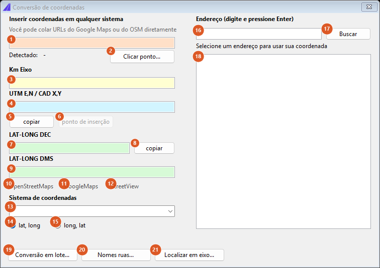
CAPCAD_GEO_POINT_IDENTIFY freshly opened, with no input: the three map links and the insert-point button start disabled. The capture is of a Portuguese session — the numbering is the same in both editions, and the tables below give the English captions.
Besides the numbered controls, the form shows the headings Insert coordinates in any system and Address (type and press Enter), the hint You can paste Google Maps or OSM URLs directly, the label Detected: with the type recognised (UTM, LL or -), the labels Alignment km, UTM E,N / CAD X,Y, LAT-LONG DEC, LAT-LONG DMS and Coord system, and a grey status line at the foot of the left column.
Input (top left)
| # | Control | What it does |
|---|---|---|
| 1 | Input box | The text is re-evaluated on every keystroke. It takes a pair separated by a comma or by a tab, with or without hemisphere letters (S on the first value and W or O on the second flip the sign), in decimal degrees, degrees-minutes (23D33.03'S) or degrees-minutes-seconds (23°33'01.87"S). Text starting with http is handled first: Google Maps and OpenStreetMap links are reduced to lat,long and only then evaluated. Classification is by range: the pair is read as geographic when the first value is between −180 and 180 and the second between −90 and 90; anything else is read as projected. |
| 2 | Click point… | Hides the form, asks for a point in the drawing, writes x,y with three decimals into box 1, re-evaluates and shows the form again. |
Readings (left column)
| # | Control | What it does |
|---|---|---|
| 3 | Alignment km | The station of the point projected onto the first element of the project's alignment, as 0+000 (whole kilometres, +, then the metres in three digits). Empty when no alignment is loaded, or when the point does not project onto it. Read-only. |
| 4 | UTM E,N / CAD X,Y | The projected pair, to three decimals. For a projected input this is the value you typed; for a geographic input it is the result of converting into the system in box 13. Read-only. |
| 5 | copy (projected pair) | Copies box 4 to the clipboard; the status line confirms. |
| 6 | insert point | Inserts a POINT entity at the projected coordinate read, on the current space and layer. Only enabled when there is a valid latitude-longitude — that is, when the conversion worked. |
| 7 | LAT-LONG DEC | Latitude and longitude in decimal degrees to eight places, in the order chosen at 14/15. Read-only. |
| 8 | copy (geographic pair) | Copies box 7. |
| 9 | LAT-LONG DMS | The same pair in degrees-minutes-seconds, as 23°33'01.87"S,46°37'59.91"W. The hemisphere letter follows the sign (N/S for latitude, E/W for longitude), and rounding never produces 60 seconds. Read-only. |
Maps (below the readings)
| # | Control | What it does |
|---|---|---|
| 10 | OpenStreetMaps | Opens openstreetmap.org centred on the coordinate read, with a marker, at zoom 18. |
| 11 | GoogleMaps | Opens google.com/maps on the coordinate read, at zoom 18. |
| 12 | StreetView | Opens Street View on the coordinate read. |
All three links (and button 6) stay disabled until there is a valid geographic coordinate: for a projected input that means the conversion has to have succeeded.
System and order (bottom)
| # | Control | What it does |
|---|---|---|
| 13 | Coord system | The system used to convert between projected and geographic. It is filled with the system the acquisition chain resolves for the drawing; if the chain returns nothing, the list opens empty and conversions fail, with a message on the status line asking you to set a coordinate system. Typed text is accepted. |
| 14 | lat, long | The first value in box 1 is the latitude. Default. |
| 15 | long, lat | The first value in box 1 is the longitude. This also swaps the order of outputs 7 and 9. |
Address (right column)
| # | Control | What it does |
|---|---|---|
| 16 | Address box | The address to look for. Enter starts the search. |
| 17 | Search | Queries the Google Places service with the text in box 16 and fills list 18. The call is synchronous: the form is frozen until the answer arrives, and the status line shows the search text before it and whatever the service returned after it — including quota-exceeded and invalid-key cases. |
| 18 | Address list | Selecting a result writes its coordinate into box 1 and re-evaluates everything: station, projected, decimal, DMS and the links all follow. The status line then shows the full address. |
Footer
| # | Control | What it does |
|---|---|---|
| 19 | Batch conversion… | Runs CAPCAD_BATCH_GEO_CONVERT — see Batch and entity coordinate conversion. |
| 20 | Street names… | Opens the labelling form (CAPCAD_LABEL) straight on its street page. |
| 21 | Localizar em eixo… | Opens the Station Navigator form as a modal dialog. On this path it is limited — see Notes. This button has no English caption: it reads Localizar em eixo… ("locate on alignment") in every language. |
The coordinate-system form
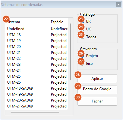
CAPCAD_GEO_CRS. The capture is of a Portuguese session in a Brazil profile, so the BR catalogue comes pre-selected; in any other profile the catalogue selected is "All".
Above the list the form shows the column headings System and Kind, the frame titles Catalogue and Record on, and, when a project and an alignment are loaded, a line reading Loaded: <project>\<alignment>. A second label shows the system currently in force.
| # | Control | What it does |
|---|---|---|
| 22 | System list | Two columns: the system string and its kind (Projected, Lat-Long, Grid, Undefined). On opening, the system currently in force is pre-selected and the list scrolls to it; failing that, the form tries UTM- plus the last zone used in the session. |
| 23 | BR | The catalogue that ships with the Brazil profile: Undefined, UTM-18 to UTM-26, UTM-18-SAD69 to UTM-26-SAD69, and WGS-84. |
| 24 | UK | The British catalogue: LSG, BNG, WGS-84, ETRS-89 (GridInQuestII), OSD-36 and OS GRID. None of these six resolve — see below. |
| 25 | All | WGS-84, Undefined, BNG, the Civil 3D system when the drawing has one, and then UTM-01S/UTM-01N through UTM-60S/UTM-60N. This is the one selected outside the Brazil profile. |
| 26 | Project | The chosen value is written to the project configuration. Default. A confirmation message follows. |
| 27 | Alignment | The value is written as a top-level property in the active alignment's .capcad file. With no alignment, the form switches itself back to Project before writing. |
| 28 | Apply | Writes according to 26/27. With no active project it writes to the dwg and, for systems that do not come from Civil 3D, warns that no project or alignment was set and that the value went to the dwg. After writing, the CAD status bar is refreshed. Choosing Undefined writes an empty value, which erases the setting. |
| 29 | Google Maps point | Hides the form and runs CAPCAD_GEO_LINK_MAPS (click a point, Google Maps opens on it) — see KMZ, geo formats and map links. |
| 30 | Close | Hides the form. |
What actually converts
The catalogues offer far more system strings than actually convert. A conversion is available for exactly two datums over exactly two zone bands:
| System string | Resolves? | EPSG |
|---|---|---|
EPSG:<code> |
yes, for any code in the EPSG database | as given |
UTM-<z> / UTM-<z>S, z = 17…25 |
yes — SIRGAS 2000, south | 31960 + z |
UTM-<z>N, z = 11…22 |
yes — SIRGAS 2000, north | 31954 + z |
UTM-<z>-SAD69, z = 17…25 south |
yes — SAD 69, south | 29170 + z |
UTM-<z>N-SAD69, z = 11…22 north |
yes — SAD 69, north | 29157 + z |
any UTM- zone outside those bands |
no | — |
WGS-84 |
no | — |
BNG |
no | — |
LSG, ETRS-89 (GridInQuestII), OSD-36, OS GRID |
no | — |
Those two zone bands are South American coverage. In practice: use UTM-17S to UTM-25S and UTM-11N to UTM-22N, or write an explicit EPSG:<code>, which is the only way to reach a projection outside that grammar.
Three consequences worth stating plainly:
WGS-84andBNGare in the catalogues but the converter does not accept them as system strings. Recording either and then usingCCfails the conversion, with a message on the status line. Some commands treatWGS-84as a special case (they pass the coordinate through unconverted); the identification form does not. To work in degrees, leave the drawing in a UTM zone and read the LAT-LONG boxes.- The UK catalogue does not convert in this version. All six entries fail to resolve,
BNGincluded — andBNGis also the United Kingdom profile's culture default when nothing else in the chain answers. A drawing in a UK profile with no explicit system therefore ends up on a system that cannot convert, andCAPCAD_GEO_UK_BOUNDARYreports a failed conversion (see Coordinate grid, points grid and the British grid). UTM-23andUTM-23Sare the same system. A zone written with no hemisphere is south and SIRGAS 2000; the-SAD69suffix swaps the datum, and the two differ by tens of metres at the same point — the offset between SAD 69 and SIRGAS 2000.
The round trip closes: a projected pair converted to geographic and back returns the same eight decimal places, and the DMS reading agrees with them.
What the input box accepts
Every line below was passed through the box-1 parser itself.
| You type | Read as | Note |
|---|---|---|
-23.550520,-46.633309 |
−23.550520 / −46.633309 | The normal case: comma separating, dot decimal. |
333000,7394000 |
333000 / 7394000 | Detected as UTM. |
23°33'01.87"S,46°37'59.91"W |
−23.550519 / −46.633308 | DMS with hemisphere letters. |
23D33.031'S,46D37.998'W |
−23.550517 / −46.633300 | Degrees and minutes, with D in place of °. |
45,45 |
45 / 45 | Detected as LL, because both fit the geographic ranges. |
-23.550520 -46.633309 |
fails | A space is not a separator in this box; use a comma or a tab. |
-23.55; -46.63 |
fails | Nor is a semicolon. |
-23,55,-46,63 |
−23 / 55 | Comma decimals: read wrongly, and with no warning. See Notes. |
abc |
fails | The status line reports that the input could not be interpreted. |
Remembered between sessions
Neither form keeps any option between sessions. What persists is the recorded value: the coordinate system written to the project, the alignment or the dwg by CAPCAD_GEO_CRS, and the "last system used", which lives only as long as the CAD session and is updated by the GIS commands that import data.
Notes
- Comma decimals in the input box are read as separators.
-23,55,-46,63returns −23 and 55, accepted as valid, with no message. Use a dot decimal. - Input with no comma, such as
600000E7419000N, is not accepted. Write the pair with a comma. - Older datums are approximate. The transformations use Helmert parameters, without NTv2 grid files. Modern systems (SIRGAS 2000, WGS 84, ETRS 89) are exact; SAD 69 and other older datums land within 1 to 2 m. Enough to locate and visualise, not for geodetic use.
CAPCAD_GEO_POINT_IDENTIFY› Localizar em eixo… opens the Station Navigator without its link to the drawing. On this path the station box, the zoom button and the two identify buttons are not available, and the alignment's station range does not appear. For the full form, runCAPCAD_ALIGNMENT_STATION_GOTO(shortcutKM) — see Station Navigator. The reverse path works: the Navigator's Localizar button closes the form and callsCAPCAD_GEO_POINT_IDENTIFY.- The address search depends on the network and on a quota. It is a synchronous call to Google Places with the key that ships with CapCad; when the daily quota is exceeded, the service's own message appears on the status line.
CAPCAD_GEO_CRS_QUERYopens no form and asks nothing. It only reports what the acquisition chain returned, with the default parameters (it does not try the last used, and it does not prompt).CAPCAD_GEO_LATLONis English-only. The point prompt (Pick a point (Esc to finish):) and the box that shows the result (Clicked / Coordinate system / Lat,Lon / (copied to clipboard)) have no other language. With no coordinate system set, the command writes "No coordinate system for this drawing — set one first (eixo / dwg / project)" and ends: it does not openCAPCAD_GEO_CRSfor you, so run that first.- Some prompts and status messages are Portuguese in an English session, including the point prompt of Click point…, the copy confirmation, the write confirmation and the two conversion-failure messages.
- Running
CCorCAPCAD_GEO_CRSagain with the form open does not open a second one. Both are modeless and single-instance: the command only brings the existing form to the front.