This page describes a single-country tool. Both commands talk to Brazilian national services and nothing else: the datasets, the administrative divisions, the road codes and the UTM zone list are all Brazil's. There is no equivalent for another country here, and the commands cannot be pointed at another country's servers. If you work outside Brazil and want the same kind of result — official boundaries, a road network, place names, drawn straight into the CAD in your own coordinate system — use the ArcGIS Server assistant for any public ArcGIS REST endpoint, or the OpenStreetMap extractor, both on Importing external geographic data. This page is here because the commands exist in every build and you may meet them on the ribbon.
| Commands | CAPCAD_GEO_BR_DATA (national mapping-agency datasets) and CAPCAD_GEO_BR_DNIT_SNV (federal highway network and its road-marking programme tabs) |
| Shortcut | none |
| Ribbon | CapCad tab › GIS panel › Data split button › Dados geográficos Brasil and Dnit SNVs; Dnit e BR-Legal also appears on the Properties panel |
| Category | GeoData |
| Forms | GeoBrasilForm, title "Dados geográficos Brasil IBGE", eight tabs (modeless); SnvForm, title "DNIT SNV assistant", four tabs (modeless) |
| Hosts | AutoCAD, BricsCAD, GstarCAD, ZWCAD, ARES Commander (both commands) |
| Also opened by | The DNIT SNVs button of the GIS Library (CAPCAD_GIS_BR_LIBRARY) opens the SNV assistant |
A national base map straight into the drawing, already in your zone. No downloading a shapefile, hunting for the right converter and finding out afterwards that the municipality landed 200 km from the alignment.
- Straight from the official services. The national mapping agency's layers (states, municipalities, country boundary, geographic names) and the federal highway network with its section codes.
- Converted as it draws. Every vertex leaves WGS-84 and arrives in the zone you chose; the zone can be detected from the data itself.
- You choose the clip. By name, by state, by the screen, by a rectangle, by two selected entities or by a single click.
- One layer per feature, with its own colour. The municipality or state name becomes the layer name, and the colour is stable for the same name.
- The streets of a whole municipality. Street centrelines come in on one layer, or one layer per street.
- The road section table becomes an alignment property. The start-kilometre × section-code table is written onto the project's alignment, for the reports to use later.
What it does
Both commands do the same thing in three steps: query a public service, convert the result from WGS-84 into the chosen coordinate system, and draw it in model space on its own layers. What changes is the source and the clip.
CAPCAD_GEO_BR_DATA covers the national mapping agency's holdings, in eight tabs:
- Municípios (municipalities) and States — polygons of the administrative divisions, by name or by geographic clip.
- Brazil boundaries — the outline of the country, optionally with the 6° meridians that separate the UTM zones and a label per zone.
- Streets — the street centrelines of one municipality.
- Projeto Rios do Brasil (a rivers project) — hydrography from a local dataset (rivers and water bodies, basins, hydrographic regions), filtered by a rectangle you draw.
- Downloads — a ready-made dwg of the boundaries for one zone, downloaded from the CapCad server and opened.
- Hydrography — the agency's geographic-names query by bounding box, with a button to undo what was drawn.
- Busca Topônimos (place-name search) — searches a name in the national geographic-names database and draws whatever it finds.
CAPCAD_GEO_BR_DNIT_SNV covers the federal highway authority. Its main tab carries the national road-network table in a BR → state → code cascade, draws the corresponding federal-highway layer, and writes a simplified version of the table as an alignment property. The other three tabs belong to a federal road-marking programme: migrating horizontal-marking material, the specification lists for vertical signage, and quality control.
The zone is the pivot for everything. The bottom bar of CAPCAD_GEO_BR_DATA and the Zone box of the SNV assistant feed the conversion. <Detect> lets the program infer the zone from the longitude of the data returned — but several options (boundaries, streets, hydrography, downloads, clips by screen or by click) require an explicit zone and warn if you leave it on <Detect>.
Language.
GeoBrasilFormhas almost no English captions: in an English session most of its buttons, tabs and check boxes read in Portuguese, and so do many of the SNV assistant's. The tables below quote the caption as the software shows it, with a gloss in brackets where it is Portuguese. Most status-line messages are English in every language.
Workflow
Bringing in a municipality or a state
- Run
CAPCAD_GEO_BR_DATA. If the drawing has a coordinate system set, it already appears in the Zone box (10) and the Detectado: label confirms it. - On the Municípios tab, choose the name in box 1 (the list holds 5,249 municipalities; typing autocompletes) and click Desenhar Munícipio por nome (2) [draw municipality by name]. Or go to States, choose the state (17) and click Desenhar UF por nome (18) [draw state by name].
- The status line shows Fetching…, then how many features came back, how many polylines were drawn, and in which zone.
- With Zoom to (3 or 22) ticked, the view goes to what was drawn.
Bringing in the streets of a stretch
- Choose an explicit zone at 10.
- Streets tab › Selecionar area (25) [select area]. Click two corners in the drawing. The program identifies the municipality at the first corner, downloads that municipality's dataset (once per session) and draws only what falls inside the rectangle.
- Todos do município (26) [all of the municipality] does the same with no clip, from a single point clicked inside the municipality — with a warning first, because it is slow.
Bringing in the road network and writing it onto the alignment
- Run
CAPCAD_GEO_BR_DNIT_SNV. The table is downloaded on opening; if the server does not answer, the command warns and the form opens empty. - Choose the BR (48) and the state (49). The section-code list (50) and the table (52) filter themselves, and the counter under the table says how many sections are left (
Total SNVs: n). - Check the Zone (51) and click one of the five draw buttons (62 to 66) for the clip you want.
- To take the table to the alignment, click Set eixo SNV (59): the simplified list in box 58 (start kilometre in metres + section code) is written to the
SNVproperty of the alignment. If one is already there, the command asks before overwriting.
The geographic-data form
The form has eight tabs and one common bottom bar. The numbers are unique on this page: 1 to 47 in GeoBrasilForm, 48 to 75 in SnvForm. Numbers 10 to 16 are the bottom bar, and appear on all eight tabs.
Tab 1: Municípios (municipalities)
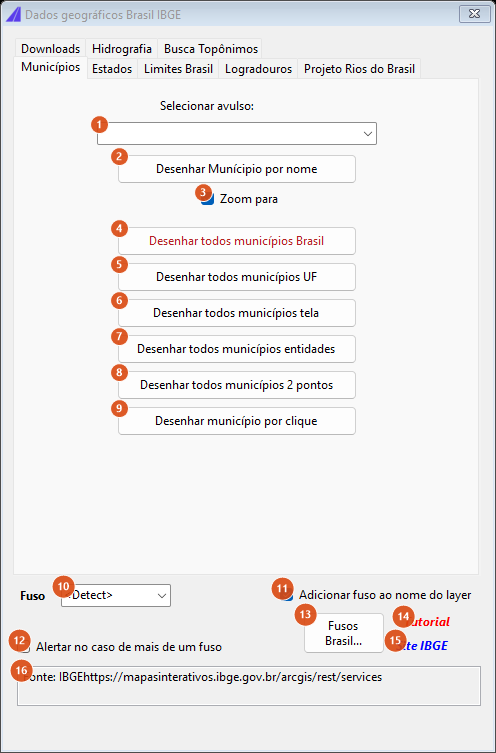
The Municípios tab with the common bottom bar. The first red button is disabled in this version. All captures on this page are of a Portuguese session; the numbering is the same in both editions — and most of these captions are Portuguese in an English session too.
| # | Control | What it does |
|---|---|---|
| 1 | Selecionar avulso | The municipality name in the national dataset's own spelling: upper case, with accents. The list holds 5,249 names and autocompletes what you type. A name outside the list is not queried: the status line says it was not found and asks you to check the spelling. |
| 2 | Desenhar Munícipio por nome | Queries the municipality service by name and draws the polygon on GIS_BRASIL_MUNI_<NAME>. |
| 3 | Zoom to | After drawing by name, takes the view to the result. Ticked by default. The geographic clips (6 to 9) do not zoom. |
| 4 | Desenhar todos municípios Brasil | Disabled: the status line answers that the option is switched off and to contact support. |
| 5 | Desenhar todos municípios UF | Not available in this version: the status line says so. |
| 6 | Desenhar todos municípios tela | Uses the current view extent as the clip. Requires an explicit zone. |
| 7 | Desenhar todos municípios entidades | Asks for a selection and makes one query per entity, using each one's bounding box. Requires an explicit zone. |
| 8 | Desenhar todos municípios 2 pontos | Two clicks define the clip rectangle. Requires an explicit zone. |
| 9 | Desenhar município por clique | One click: the clip is the point itself, so the municipality containing it comes back. Requires an explicit zone. |
Bottom bar (all tabs)
| # | Control | What it does |
|---|---|---|
| 10 | Zone | UTM-18 to UTM-25 and <Detect>. Filled on opening with the system resolved for the drawing. With <Detect>, the zone is inferred from the longitude of the data returned and the box then shows it. |
| 11 | Add fuso to layer name | Appends _UTM-NN to every layer created, so that data for the same municipality in different zones do not mix. Ticked by default. |
| 12 | Alertar no caso de mais de um fuso | With an explicit zone chosen, checks whether the data cross more than one zone and shows a box listing which. |
| 13 | Brazil UTM zones… | Not available in this version: the status line says so. |
| 14 | Tutorial | Opens the CapCad video about this tool. |
| 15 | IBGE site | Opens the mapping agency's service portal in the browser. |
| 16 | Fonte | A read-only text box with the address of the service used. |
Tab 2: States
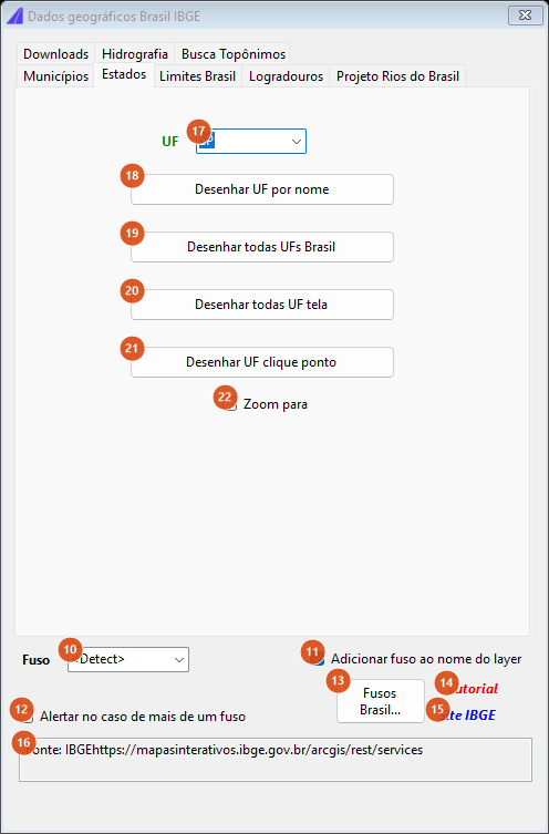
The States tab: the same four ways of clipping, now over the states.
| # | Control | What it does |
|---|---|---|
| 17 | UF | The 27 state abbreviations; SP comes selected. |
| 18 | Desenhar UF por nome | Queries by the sigla field and draws on GIS_BRASIL_UF_<CODE>. |
| 19 | Desenhar todas UFs Brasil | Queries with no filter: all 27 states at once. |
| 20 | Desenhar todas UF tela | Clip by the view extent. Requires an explicit zone. |
| 21 | Desenhar UF clique ponto | Clip by one clicked point. Requires an explicit zone. |
| 22 | Zoom to | Takes the view to the result of 18 and 19. Unticked by default. |
Tab 3: Brazil boundaries
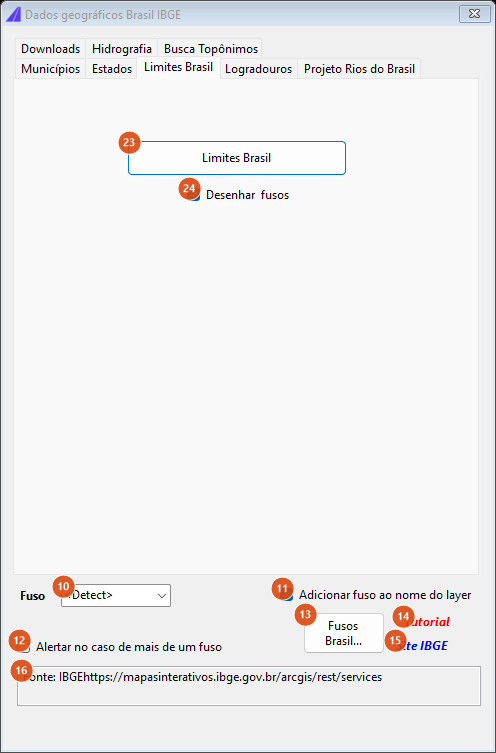
The Brazil boundaries tab.
| # | Control | What it does |
|---|---|---|
| 23 | Brazil boundaries | Downloads the general country layer and draws the outline on COUNTRY_LIMITS_BRASIL_<zone> (colour 64). Requires an explicit zone. |
| 24 | Desenhar fusos | Along with the outline, draws the 6° meridians that bound the UTM zones, from latitude −50 to 30, within the country's longitude range, plus a UTM-nn text per band on layer UTM_ZONES_TEXT (colour 51, height 200,000 units). Ticked by default. (The caption has a double space.) |
Tab 4: Streets
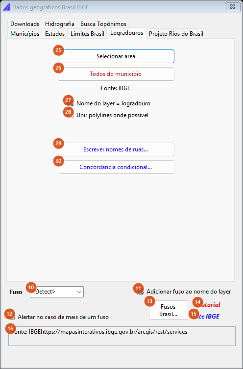
The Streets tab. The last two buttons are pending.
| # | Control | What it does |
|---|---|---|
| 25 | Selecionar area | Two clicks define the rectangle. The first corner identifies the municipality (a point query on the service); that municipality's dataset is downloaded once and kept in memory for the rest of the session. Only what falls inside is drawn. Maximum area 1,000,000 km²; minimum 100 m². Requires an explicit zone. |
| 26 | Todos do município | One click inside the municipality, no clip. It asks first, because converting a whole municipality is slow. Requires an explicit zone. |
| 27 | Layer name = logradouro | Ticked (the default), each street goes onto a layer named after it; unticked, they all go onto the single layer CAPCAD_LOGRADOUROS (colour 2). |
| 28 | Unir polylines onde possível | Not available in this version. |
| 29 | Escrever nomes de ruas… | Not available in this version: the status line points at the labelling form. |
| 30 | Fillet condicional… | Not available in this version: the status line points at the curve utilities. |
Tab 5: Projeto Rios do Brasil (rivers)
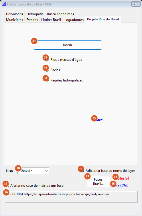
The Projeto Rios do Brasil tab.
| # | Control | What it does |
|---|---|---|
| 31 | Inserir | Asks for a rectangle, downloads (the first time) the dataset chosen at 32-34, filters it by the rectangle and draws it. Requires an explicit zone. |
| 32 | Rios e massas d'água [rivers and water bodies] | Hydrography dataset, layers GIS_RIOSBR_AGUA_*, colour 150, maximum area 1,000,000 km². Default. |
| 33 | Basins | Loads the hydrographic-regions dataset: layers GIS_RIOSBR_REGIOES_*, colour 164, no area limit. See Notes. |
| 34 | Regiões hidrográficas [hydrographic regions] | Loads the basins dataset: layers GIS_RIOSBR_BACIAS_*, colour 141, no area limit. See Notes. |
| 35 | Site | Opens the source project's page in the browser. |
Tab 6: Downloads
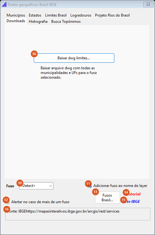
The Downloads tab.
| # | Control | What it does |
|---|---|---|
| 36 | Download boundaries dwg… | Asks whether you want to download LIMITES BR IBGE - FUSO nn.dwg (municipalities and states for that zone), saves it in the project's exports folder and opens the file in the CAD. Requires an explicit zone. |
Tab 7: Hydrography
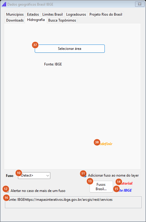
The Hydrography tab.
| # | Control | What it does |
|---|---|---|
| 37 | Selecionar área | Two clicks define the rectangle, which is converted to latitude-longitude and sent to the agency's geographic names query by bounding box (validated records only). Whatever comes back is drawn on layer GIS_IBGE_NOMES (colour 130). Requires an explicit zone; no area limit. |
| 38 | Reset | Erases from the drawing everything this tab drew in this session, and says how many items it removed. It does not reach anything drawn before the form was opened. |
Tab 8: Busca Topônimos (place-name search)
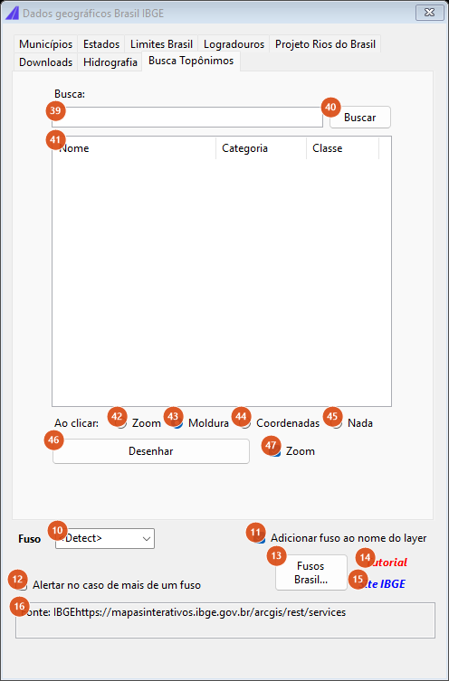
The Busca Topônimos tab, with the result list empty.
| # | Control | What it does |
|---|---|---|
| 39 | Search: | The name to look for in the national geographic-names database. Enter starts the search. |
| 40 | Search | Queries the service and fills list 41. The status line says how many results came back. |
| 41 | Result list | Three columns: Nome [name], Category and Class. |
| 42 | Ao clicar: Zoom | Selecting a result zooms the view to a 1 km frame around it. Requires an explicit zone (with <Detect>, selecting does nothing). |
| 43 | Ao clicar: Frame | Frames the result in a wider, 4 km box. Default. |
| 44 | Ao clicar: Coordinates | Writes the name, the latitude, the longitude and the projected pair on the command line. |
| 45 | Ao clicar: None | Selecting a result does nothing. |
| 46 | Desenhar | Draws the selected result. The geometry comes from the search response itself: if there are lines or polygons, they are drawn; otherwise a POINT. The layer is GIS_IBGE_BNGB_<NAME>. With <Detect> in the zone box, the zone is inferred from the result's own longitude. |
| 47 | Zoom | After Desenhar, takes the view to what was drawn (for a point, a 1 km frame). Ticked by default. |
The SNV assistant
Tab 1: SNVs
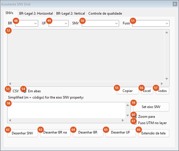
The SNVs tab, before choosing a BR. The table and the simplified list are empty.
| # | Control | What it does |
|---|---|---|
| 48 | BR | The federal highways present in the table, without repetition. Filters the state, the code and the table. |
| 49 | UF | The states present in the chosen highway (all of them while no highway is chosen). |
| 50 | SNV | The section codes left after filtering; the first is selected automatically. |
| 51 | Zone | The Brazilian systems catalogue. Filled with the drawing's system on opening, and updated to the last used on each draw. With no value, the draw buttons ask you to set a coordinate system. |
| 52 | Table | The filtered table, with a header row. Read-only. |
| 53 | CSV | Shows the table comma-separated. |
| 54 | Tabbed | Shows the table tab-separated — the format that pastes straight into a spreadsheet. Default. |
| 55 | Copy | Copies the displayed table to the clipboard. |
| 56 | Excel | Opens the filtered table in Excel. |
| 57 | All | Opens the whole table, unfiltered, in Excel. |
| 58 | Simplified list | Two columns — start kilometre converted to metres and the section code — recomputed on every change of highway/state. This is what the alignment property receives. It stays empty until both a highway and a state are chosen. |
| 59 | Set eixo SNV | Writes the list from 58 into the SNV property of the project's alignment. If one is already there, it asks before overwriting. |
| 60 | Zoom to | Takes the view to whatever buttons 62 to 66 draw. Ticked by default. |
| 61 | UTM zone in layer | Appends the zone to the name of the layer created by the import. |
| 62 | Draw SNV | Draws only the section whose code is chosen at 50. |
| 63 | Draw BR in UF | Draws the chosen highway, limited to the chosen state. |
| 64 | Draw whole BR | Draws the whole highway, across every state. |
| 65 | Draw whole UF | Draws every federal highway in the chosen state. |
| 66 | Screen extent | Draws whatever falls inside the current view, with no highway/state filter. |
All five draw buttons go through the same importer: it queries the federal-highway service, warns if the result exceeds 1,000 features with no clip, converts into the zone, creates one layer per value of the vl_codigo field, assigns random colours and applies 50 % transparency. When it finishes, a box reports how many items were drawn, in which system, and in how many seconds.
Tab 2: Horizontal marking material
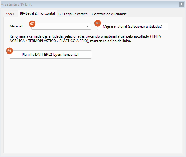
The BR-Legal 2: Horizontal tab. This tab belongs to a Brazilian federal road-marking programme and its layer naming convention.
| # | Control | What it does |
|---|---|---|
| 67 | Material | TINTA ACRÍLICA (acrylic paint), TERMOPLÁSTICO (thermoplastic) or PLÁSTICO A FRIO (cold-applied plastic). |
| 68 | Migrar material (selecionar entidades) | Asks for a selection. For every entity whose layer name contains one of the three materials, it creates (or reuses) the layer with that part of the name swapped for the chosen material, keeping the source layer's linetype, and moves the entity onto it. The command line reports how many entities migrated. With no material chosen, it asks you to choose one. |
| 69 | Planilha DNIT BRL2 layers horizontal | Downloads the programme's layer workbook from the CapCad server and opens it. |
Tab 3: Vertical signage specification
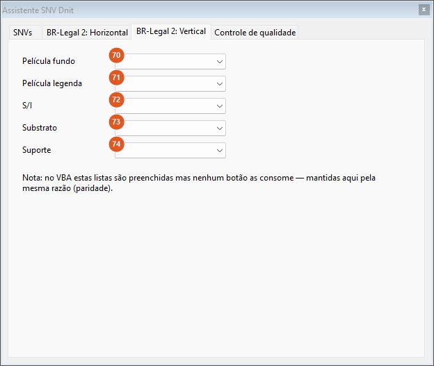
The BR-Legal 2: Vertical tab. The five lists are not available in this version.
| # | Control | What it does |
|---|---|---|
| 70 | Película fundo [background sheeting] | I, III, IV, X. Not available in this version. |
| 71 | Película legenda [legend sheeting] | I, III, IV, X. Not available in this version. |
| 72 | S/I | S or N. Not available in this version. |
| 73 | Substrate | AÇO (steel), ALUMÍNIO (aluminium), POLIÉSTER (polyester), ACM. Not available in this version. |
| 74 | Support | MADEIRA (timber), POLIMÉRICO (polymer), METÁLICO (metal). Not available in this version. |
Tab 4: Quality control
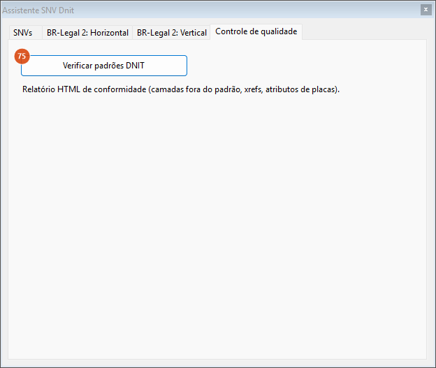
The quality-control tab: one button, not available in this version.
| # | Control | What it does |
|---|---|---|
| 75 | Verificar padrões DNIT | Not available in this version: it shows a message saying so. |
What gets drawn
| Source | Layer | Colour |
|---|---|---|
| Municipalities | GIS_BRASIL_MUNI_<NAME> (+ _UTM-nn) |
derived from the name, stable |
| States | GIS_BRASIL_UF_<CODE> (+ _UTM-nn) |
derived from the name, stable |
| Country boundary and zone meridians | COUNTRY_LIMITS_BRASIL_<zone> |
64 |
| Zone labels | UTM_ZONES_TEXT |
51 |
| Streets, single layer | CAPCAD_LOGRADOUROS |
2 |
| Streets, one per street | the street name | 2 |
| Rivers and water bodies | GIS_RIOSBR_AGUA_* |
150 |
| Dataset behind the Basins radio | GIS_RIOSBR_REGIOES_* |
164 |
| Dataset behind the Regiões hidrográficas radio | GIS_RIOSBR_BACIAS_* |
141 |
| Geographic names (Hydrography tab) | GIS_IBGE_NOMES |
130 |
| Place-name search | GIS_IBGE_BNGB_<NAME> |
derived from the name |
| Federal highways / road sections | GIS_<vl_codigo>-<value> (+ _zone) |
random, 50 % transparency |
Characters forbidden in a layer name (< > / \ " : ; ? * | = ' ,) are replaced with _.
Remembered between sessions
Neither form keeps its options between sessions: the tick boxes return to their defaults on every opening. What persists is the drawing's zone (written by CAPCAD_GEO_CRS, see Coordinates and the coordinate system), the SNV property written onto the alignment, and the downloaded files — hydrography and street datasets stay in the project's exports folder and are not downloaded again; within the same session they are not re-parsed either.
Notes
- The two hydrography radio buttons load each other's dataset. Choosing Basins loads the hydrographic regions dataset, and choosing Regiões hidrográficas loads the basins; the layer names (
GIS_RIOSBR_REGIOES_*andGIS_RIOSBR_BACIAS_*) follow the dataset, not the radio button's label. - The
<Detect>zone option is not good for everything. Country boundaries, streets, hydrography, geographic names, downloads and every clip by screen, entity, two points or click require a zone chosen by hand. In those cases the status line asks for an explicit zone. - Most of this form is Portuguese in an English session, and most of its status messages are English in every language (Fetching…, Downloading…, Nothing found in the area., Draw failed:, Area too big…). The same is true of the SNV assistant's Simplified (m + código) for the eixo SNV property: label and its Set eixo SNV button.
- Four buttons are not available in this version and say so on the status line: Fusos Brasil… (13), Escrever nomes de ruas… (29), Fillet condicional… (30) and, in the SNV assistant, Verificar padrões DNIT (75). Unir polylines onde possível (28) is not available either, and Desenhar todos municípios Brasil (4) is disabled.
- Street centrelines come in as separate segments; joining and labelling are not available in this version.
- The zone labels on the country boundary are placed at latitude −50, in the middle of each 6° band, at a fixed height of 200,000 units, which suits projected coordinates.
- Everything depends on the network. The form is frozen while it waits for an answer. A server error becomes a status-line message (or a box, in the SNV assistant, which opens empty if the table does not arrive).
- The rectangle's area is checked before the query. Under 100 m² is refused as too small; above the dataset's limit, as too large. The rectangle is converted corner by corner to latitude-longitude, so it may skew slightly against the rectangle you drew.
- The GIS Library (
CAPCAD_GIS_BR_LIBRARY) sends hydrology here. Choosing a hydrology preset there answers by pointing you at the Projeto Rios do Brasil tab of this form. - The conversion has the same coverage limits as everywhere else. The zone list here is
UTM-18toUTM-25, all of which resolve; see What actually converts for the general rule.